Wednesday, 12 February 2020

The Giant's Causeway Co Antrim - Northern Ireland 25 Jan 2020

The Giant's Causeway
Co Antrim
Northern Ireland
Distance 8km Climb 235m
Saturday 25 January 2020


I have had a totally unexpected opportunity to visit friends in Northern Ireland. While having our dinner one evening a friend suggested I visit the Giant's Causeway and so it was arranged that another friend would drop me off on his way to doing some surfing.

Arriving in the carpark I walked through the tunnel avoiding the National Trust fee for going through the gift shop. There is a direct route you can walk or you can take a bus down to the Giant's Causeway.


I however wanted to have a look around, so after a look at the map on the board I took the steps up onto the top and turned left to follow the red route along the top of the cliffs.

Approaching Weir's Snout.


Details show this is Port Ganny and I continued to Aird Snout which lies above The Causeway. It was cold up here and there was a very strong wind.


At the top of the Shepard's Steps I continued along the cliff path, I was now on the yellow trail. I would return to the Shepard's Steps later. Looking down I was above Port Noffer,


Walking the cliff path above The Amphitheatre I was above the Giant's Chimneys.


After a few photos I turned back and headed towards the Shephard's Steps.


This is the view down onto Port Noffer and The Causeway, with The Stookans a little further up.


The view from the top of the Shepard's Steps.


I am sure I read somewhere that the stone in the sea at the bottom of the cliff is The Giant's Granny?


At the bottom of the Steps I continued along the path round the bottom of the cliff. Passed The Organ.


Through the doorway.


Into The Amphitheatre and could see why the path was closed. A mass of rockfall and landslide had taken away a large section of the path.


After more photos I turned around.


Back through the doorway and into Port Noffer.


Following the path back passed The Organ and I can see why it is called The Organ.


Following the path round towards The Causeway.


I had only seen two people on the cliff paths. About four or five near the closed footpath. This is where everyone was.
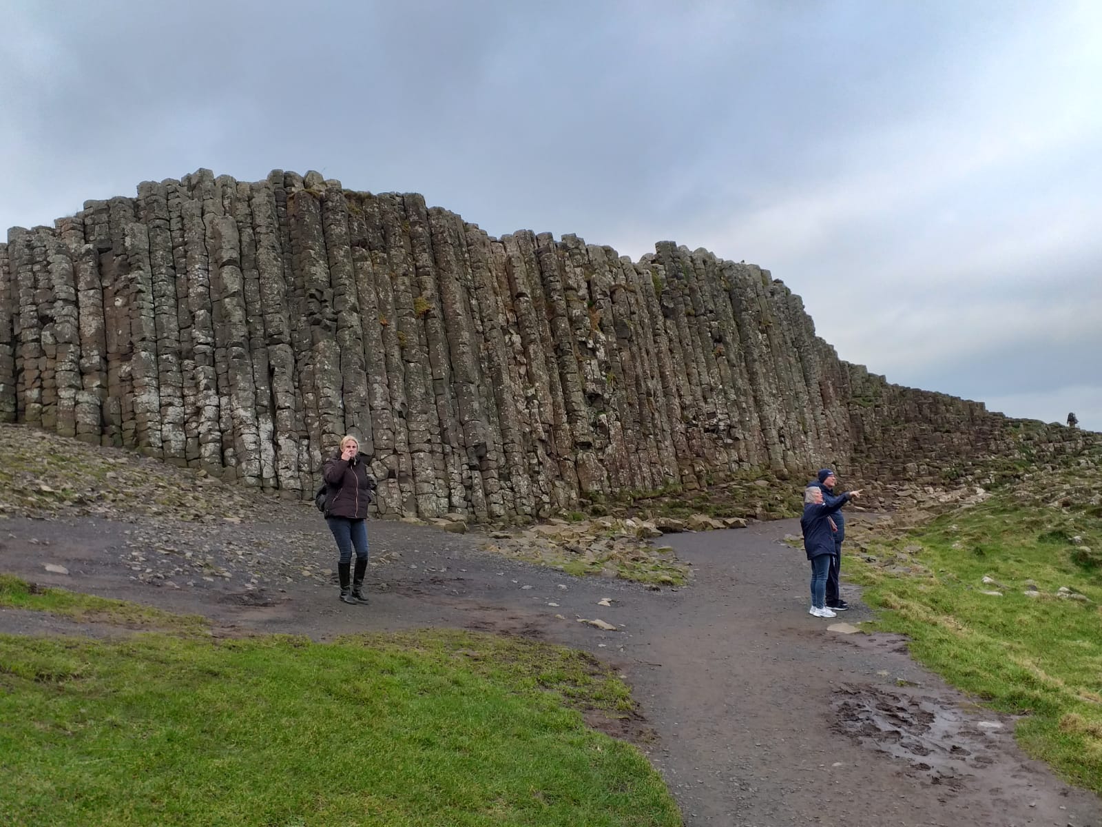


People were standing queuing to sit on the stones for photos and selfies. It was amazing seeing the hexagonal stones.


The waves looked and sounded massive in the cold Atlantic. I wondered how my friend was getting on with his surfing.


Looking up towards Aird Snout.


After taking even more photos I followed the road as it headed back to the top.


Walking up to pass The Stookans.


Walking from Portnaboe, a large stone is called the camel. I couldn't see it at the time but I can see it now in my photos. With Runkerry Head the massive cliff behind.


At the top of the road, I climbed the steps above the visitor centre as I had earlier. This time I turned right and walked the green trail. Passed the Causeway Hotel.


Along the top of Runkerry Head.


Looking eastwards I could see Portrush in the distance and hear the impact of the waves crashing on the cliffs below.


After more photos I returned towards the visitor centre. A last look at The Stookins, The Causeway through the gap and the Giant's Chimneys.


Back near the carpark I only had a few minutes to wait for my friend.


An interesting place, I will have to bring Anne here sometime. With my wandering around I had walked 8km and climbed 235m. From the visitor centre there is a direct route to The Causeway which is not as far as I walked or you could get a bus.

Thanks to my friends for a lovely day.

More to follow


Boz North
Details correct at time of walking.
Follow link to my previous walk in Northern Ireland. Magilligan Point to Mussenden Temple.
Follow link to my next walk in Northern Ireland. Lagan Towpath, Lisburn to Belfast.


Tuesday, 11 February 2020

Magilligan Point to Mussenden Temple, Co Londonderry - Northern Ireland 22 Jan 2020

Magilligan Point to Mussenden Temple and return
Co Londonderry
Northern Ireland
Distance 31km Climb 176m
Wednesday 22 January 2020


This was a totally unexpected opportunity to visit friends in Northern Ireland. One of my friends had told me about the beautiful beaches and so while he was at work I went to have a look. He dropped me off at the end of Point Road near the Magilligan Ferry Port. Which is open in the summer. It was quite cool and hazy with a little dampness in the air.


I walked to the end of the road passed The Point Bar, passed the steps down to the beach and walked up to the green gate that led me towards the Magilligan Martello Tower. According to the signs a number of Martello Towers were built around the coast against the threat of Napoleon. 


Crossing the dunes I was on the sands looking across the mouth of Lough Foyle towards Co Donegal.


I followed the sands around the Point onto the Atlantic coast. The red flags were down and so it was safe to walk along here. As I turned towards the east there was a strong wind at my back. Lying on the sand there were thousands of interesting looking sea shells along the first few hundred meters near were the mouth of Lough Foyle and the Atlantic meet. 


Waves were crashing onto the shore causing the views to be hazy through the sea spray and made the Temple look a little blurry, further to my left I could see across to Scotland and a large mountain. In my mind I thought it was possibly Ben Lomond?

The sea had left its wave patterns on the sand. It was lovely along here and I had the beach to myself. 


As I walked long I would see flocks of little running sea birds. Looking them up I think they were stints. They would fly off as I approached and land a few meters down the beach. Eventually they got the idea if they flew behind me they wouldn't be disturbed.

I passed the front of Benone Avenue, my friend had told me in the summer, people drive their cars down onto the sand and enjoy the beach. Moving their cars backwards as the tide comes in. Today there were only a couple of cars and they were high up the beach.

I started to see a few other people now but not many.


I took some photos of shells, as usual I took too many photos and cannot show them all here. When I have looked at these photos the sand comes out as a lovely shade of pink.


After a few km the high cliffs start approaching the sea and I could see high waterfalls where the water just fell off the cliff top. Stunning.


This meant there was quite a large stream to cross. Trying not to get my feet wet which unavoidable. 


A little further and more water cascaded over the cliff tops. I am not sure if these houses were used all year round or just holiday homes but they look like the water lands very close to them.


A little further along the beach more houses cluster under the cliff. The sea spray made it more difficult to see the Temple which does not look like it is getting any closer.


I was now on Downhill Beach. Another couple of streams to cross, not as wide as the first.


I could see car tracks leaving the beach by another stream and a low bridge under the railway line.


Following this pathway under the bridge I turned left back onto a footpath over the stream and under the bridge back onto the sands. This was where I collected my first Geocache of the day.


Continuing along by the sands.


Until I was almost directly under the Temple.


After a short scramble up the rocks I collected my second Geocache of the day. It was lovely and peaceful along here.


Returning back under the railway bridge I spotted a sign showing this was where they had filmed part of The Game of Thrones.

From the bridge I turned left and walked up the A2, Mussenden Road. Walking by the stream I spotted a number of bushes that were starting to have early buds.

At the top of the bank I turned left through the Lion Gates into the grounds of Downhill House.


A coffee shop was set up at the far end of the carpark. So time for a cup of coffee, a snack and a short rest. When I was ready  I set off through the walled garden passed the dovecot and ice house towards the Mussenden Temple. Signs show it was the Earl Bishop's Library, today it is used for weddings and the signs show a lot of work is being carried out to conserve it. Apparently it is one of the most photographed icons in Northern Ireland.


This is the stunning view back along the beach which I had walked.


After a few more photos I headed up towards Downhill House.


The sky looks dramatic over the House and Mausoleum.


Then across the grounds to the Mausoleum dedicated to the Bishop's brother.


A quick look at the Belvedere built as a summer house for the Bishop's daughter.


After I collected another Geocache near the carpark I left by the Lion's Gate.

It was then back down Mussenden Road. A little way down the road I realised I could collect another Geocache just down to my left so walked down Burrenmore Road onto the Ulster Way to collect my last Geocache of the day.

Returning back to Mussenden Road I walked back down the hill to Downhill.  


Under the bridge back onto Downhill Beach. There were more cars there now parked on the sand. I expect this will be really busy in the summer. I turned left and headed back along the beach.


The sky had patches of a wonderful blue colour. It was a little colder now that the sun was going down.


I noticed more cars at Benone Avenue, on my return than on my way out.

Co Donegal was getting larger with each step. The sky was blue and grey with patches of yellow. The sea was different shades of blue, grey and white. The sand was a grey and pink. Different shades of greens in the grasses on the dunes with smudges of greens in the Co Donegal countryside the whole effect was beautiful. The sound of the sea brushing on the shore had been my constant companion for the best part of the day. The strong wind from this morning had been replaced by a moderate pleasant breeze. The whole experience cannot be described.


I took loads of photos of shells but this is the only photo I have included. The sand didn't look as pink now.


It was getting darker as I walked along.

I passed the red warning flags which were still down so I continued along the beach.


Eventually I followed the sands round to the left I was nearing the mouth of Lough Foyle.


Magilligan's Martello Town popped up amongst the dunes.


I reached the steps from the beach and up onto Point Road. My friend would not be long.

I was hoping to get a photo of the sun setting on Lough Foyle. The day before my friend brought me here to see the Point and it had been a wonderful sunset on the Lough, not today though it was a little overcast.


It had been a beautiful walk. The sound of the sea had been my companion, I had hardly seen anyone but I expect when the weather turns nicer it will be full of people and visitors. Today I had walked 31km with a climb of 176m and had enjoyed every minute of it. A great day walking. 

More to follow


Boz North
Details correct at time of walking.
Next walk in Northern Ireland. The Giant's Causeway Co Antrim