Monday 18 September 2017

PW - Dufton to High Cup Nick - Cumbria 16 Sept 2017

Pennine Way
Dufton to High Cup Nick and Return
Cumbria
Distance 15km Height 400m
Saturday 16 September 2017


Today was the day. I had promised Anne a walk up to High Cup Nick since I had walked here on My Pennine Way in 2011 and I was so impressed with the views.

I had a look at a few different routes so that Anne could get the full experience of the place and the most impact of the views. With this in mind in March 2017 I walked High Cup Nick from the West returning to Dufton via Murton Pike. More recently in August 2017 I walked along High Cup Gill. I finally decided on the route we took today which is along the Pennine Way from Dufton up to High Cup Nick.

Arriving in Dufton, we were lucky to get the car into the car park.


Once ready we had a walk into the village. I pointed out, to our north the Great Dun Fell radar station. Yesterday, we had visited Cow Green reservoir and Caldron Snout, I had pointed out the radar station to our west. Today the weather was perfect although showers were predicted. After a few photos we turned back passed the house with a statue of William Shakespeare at Wesley House, then the car park and headed back along the road south east out of the village.


At the Pennine Way sign, and red flag we turned left, east along The Pennine Way. There are a number of notices on the post regarding the MOD applying to take over Murton Pike and other areas. I was glad I had walked Murton Pike when I did.


We started the steady climb east along the road and as it turned from road to track. It turned very warm and we had to remove our coats.


Large puddles of water lay in the area where a stream crosses the track. Showing they had had some heavy rainfall in the last few days. The track climbs, now changing from stone track to grass path. After passing through a couple of gates we climbed by an old disused quarry.


We had seen the start of Middletongue Crag to our right as we turned slightly north east. Cresting a rise we saw the far side of High Cup Nick as the area opened up for us. The air was a lot cooler here and we had a few drops of rain. I had visions of my last walk here and the soaking I received, that started with a few spots of rain.


There is a slight diversion on the path up to our left a short sharp climb.


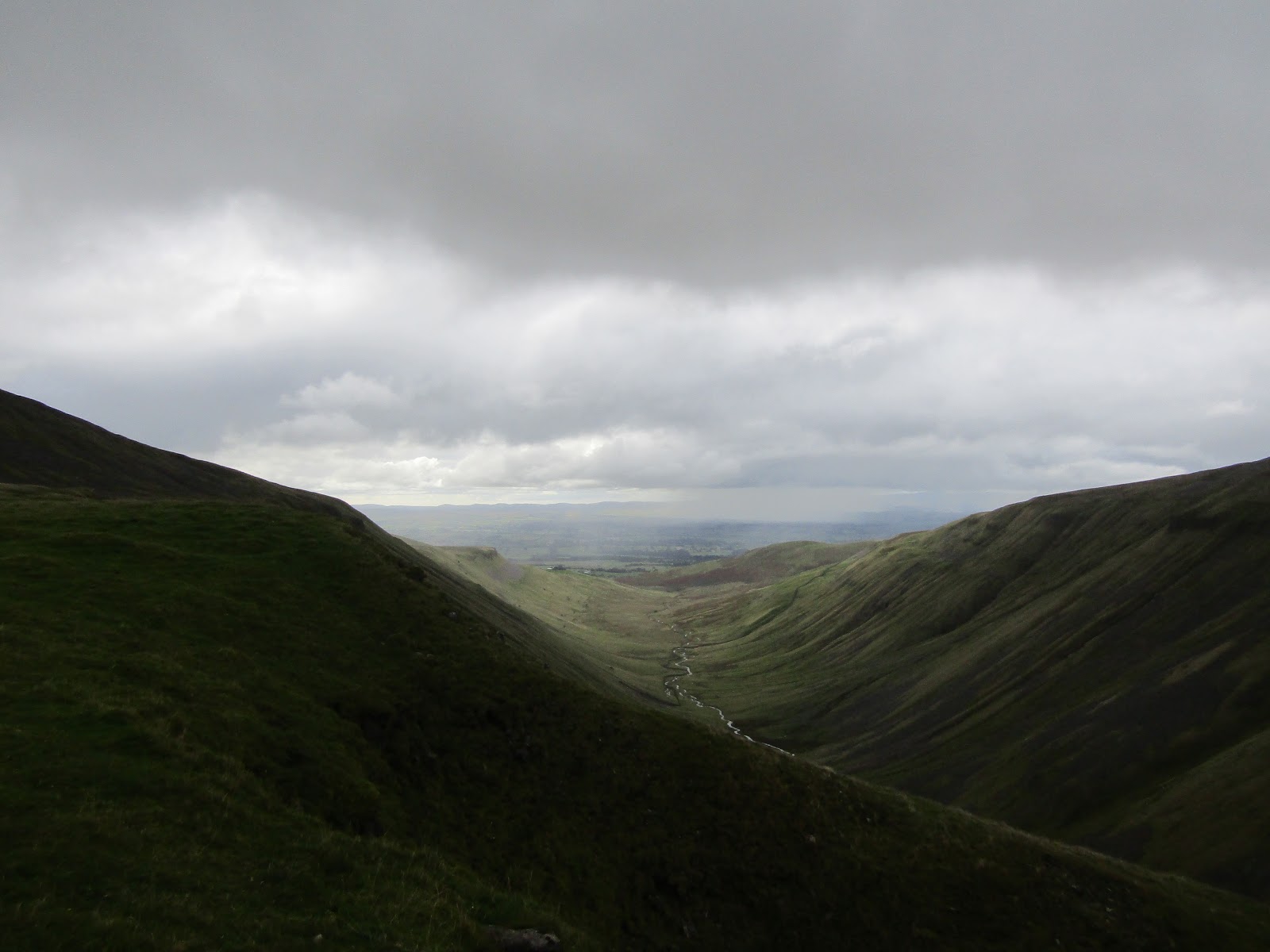
Followed by a gentle drop to cross Strands Beck then a further drop to the magnificent view of High Cup Nick.


I could see a wild pony up to our left, this was a first for me in this area.


The wind was cold so we took shelter a little down from the edge and had a drink of hot chocolate. As we had our drink we watched walkers going down the path that follows by the Gill.

After our drinks we moved across High Cupgill Head and started along the eastern edge of High Cup Nick.


The views to our south west down the valley were stunning.


After a few photos and a few hundred meters we found ourselves in bright warm sunshine so decided to sit and enjoy the views and the warmth. We could see dark clouds coming from our right the north east and the valley bottom to our left, south west. Someone was getting a soaking, and it looked like it would soon be us.


After another drink of hot chocolate we set off back along the side of High Cup Nick heading north east, just as a few splashes of rain hit.


Back across High Cupgill Head.


We saw more ponies moving down the hill. I am not sure if this is a natural feature but I noticed the ponies were all feeding, facing into the wind, while all the sheep were feeding with their backs to the wind.


The shower did not stay long and it soon stopped raining.


On our journey down hill we were hit with a few more showers that soon passed us over. A number of fell runners soon came and also passed us.


Moving away from High Cup, as we were heading further down hill the weather started turning warmer a little.


In the distance we could see the Lake District was getting a lot of rain.


From the grass path we returned to the stone track and then back to the road.


At the road junction we turned right and headed north west back into Dufton.


Leaving our boots and coats in the car we had a walk into the Stag Inn. We had walked approx 15km with approx 400m climb. The main thing was that Anne had enjoyed the walk.

It was when we left the Stag Inn after a shandy and were heading back to the car the heavens opened and we were caught out in a heavy shower. These things happen.

More to follow


Boz North
Details correct at time of walking.
If you have enjoyed reading my walk or found it useful you may also like to read other walks I have done in Cumbria or other areas. Please check out the links on the right hand side.

Follow links to previous walks to High Cup Nick.
My Pennine Way in April 2011.
High Cup Nick from the West returning via Murton Pike in March 2017.
Along High Cup Gill in August 2017.


Tuesday 12 September 2017

Waskerley Way - Lydgett's Junction to Park Head - Co Durham 11 Sept 2017

Waskerley Way
Lydgett's Junction to Park Head and return
Co Durham
Distance 31.5km Climb 350m
Monday 11 September 2017


Waskerley Way is another walk I had talked to my friend John about. It is an old railway route, looking at the map Lydgett's Junction is where many old railway routes, now walks join. There are signs for the C2C cycle route, the Consett and Sunderland Railway Path, the Lanchester Valley Railway Path and I am sure I saw a sign for the Derwent Railway Walk.

Leaving the car near Lydgett's Junction (230m) I walked up to the junction where the above paths crossed and turned right, south west onto the Waskerley Way. It was a little overcast but pleasant for walking.


A bridge took the Way over a road and I could see a caravan site down to my left. After a few hundred meters I was walking under a roadway.


Walking through trees with embankments on both sides when all of a sudden the views open up as I crossed the Hownsgill Viaduct. The wind was quite cold and strong out in the open. There were wide views on both sides.

Walking across the viaduct, in fact any viaduct or large bridge, I am missing out on the symmetry, the artistry and the beauty of any and all the viaducts or bridges I cross, which is a shame.    


On the other side I was once again under trees and between embankments. After a short while as the path turns south I crossed a narrow farm track.


It was turning warm now, and as the path turns east I saw a rainbow appear over some houses at Rowley. I was thinking of taking my coat off, as usual this would have been premature. Walking the steep bank up to the A68 at Rowley I felt a few splashes of rain, it was nothing?


Crossing the A68 the splashes started getting heavier and cyclists were stopping to put on their waterproofs. It had stopped after a few hundred meters, by the time I reached the farm at Whitehall, but was heavy again as I crossed the road at the Whitehall picnic area, a few hundred meters more.


Over the road and the Way takes on a gentle climb.


The weather was clearing again, turning warmer as the Way twisted south and levelled. From high embankments the views opened up, especially to the west.


Another climb and on my right there was a gate into a field showing Palmers Bridge. On the other side of the track there was a bench for Colin and Gavin.


Here I turned off Waskerley Way, through a gate across the track to Palmers Bridge gate and headed towards the south east.


Climbing up hill, at the top I turned right, over a farm gate into a field up to the Oxen Law trig point (342m). The views were stunning, I could see for miles.

After a cup of hot chocolate I returned back down the hill the way I had come to rejoin the Waskerley Way.


Back at Palmers Bridge gate I turned left, south westerly along the Waskerley Way.


The path dropped a little between high sides and it was lovely and warm, a little sun trap. Again I thought about taking off my coat before the gentle climb up towards the Red House. As I reached the gate I could feel a cold wind blowing, from the west, so decided to keep my coat on. Look at the tree leaning over from the west.


A sign shows the Waskerley Way is made up of two old railway lines. Blanchland to Burnhill and Bishop Auckland to Consett.

Through the gates and heading south I was now in the Burnhill Nature Reserve. The path drops and climbs a little along here. There is the remains of a high sided fence to my left. The map shows what appears to be a numbers of bunkers in the area of Burn Hill, the internet shows Burn Hill Station was used by the military.

After heading south, there is a sharp bend in the path and it turns northwards. You can see from the map this appears to be an old railway junction.

Heading towards Waskerley, just as the path was turning west I am sure I could see the Cheviots far far to my north.


Leaving Waskerley there is a long slow climb,west, I had the wind directly in my face. The wind was cold and it was strong, making walking difficult. The path has no shelter it is totally open and exposed. I did not see any cyclists going west passed Waskerley not on my outward journey. They were all heading east, downhill with the wind behind them. I had walked along part of this path in December 2016  Smiddy Shaw and Waskerley Reserervoir.


A large flock of small birds were flying in the area of Waskerley Reservoir but they were too small to make out what they were. The path levels a little after the car park at Hawkburn Head, it was still very windy. Along here I was reminded of a time I brought Callum and Declan. Declan was not impressed with the cold wind. Over to my left Park Head was in sight.

The map shows the path going through Frosterley Cut. High sides and a wall. No shelter from the wind, as the cut acts as a funnel for the wind to push down through, straight into my face.


Although Park Head is in sight it is one of those places that never gets any nearer. The more you walk towards it, the further away it gets.

A sign of the old Stockton and Darlington Railway is shown on the gate.


It looks like the iron work horse and cart has had something added since my walk here in December 2016.


Eventually I was sitting on a wall across from Park Head Station (440m) enjoying my jam sandwiches and a couple of cups of hot chocolate.


After my break I set off back the same way I had come, now the wind was behind me.


On my return, I saw that the grouse beaters were out.

In the distance far far away north east I was sure I could see the sea.

It was as I was walking down from Hawkburn Head I saw the only couple cycling uphill against the wind, all of the other had been travelling down hill, in the opposite direction. They looked happy on it mind.

From Waskerley I noticed to my left clouds of rain in the valley, pushing up to where I was headed. It was lovely warm and bright on my side of the valley and I had finally made the decision to take my coat off.


From the sharp bend north towards Red House, it looked more certain that I would be walking into the rain.


Passed Red House I thought I had best put my coat back on. I was just in time, fat heavy rain drops started to fall. Turning to sheets of raining blowing across.


They were getting heavier by the time I reached Whitehall picnic site. The rain was steadily continuing as I passed through Rowley. Then the sun made a brief appearance as I approached Hownsgill Viaduct.


Over the viaduct it was a short step up to the path under the roadway.


Then I was back at Lydgett's Junction, it was warm and sunny now.


Returning to the car I was tired I had covered 31.5km with a climb of 350m. It had been a mixed day with the weather, still I had enjoyed it.

More to follow


Boz North
Details correct at time of walking.
If you have enjoyed reading my walk or found it useful you may also like to read other walks I have done on The Waskerley Way or other areas. Please check out the links on the right hand side.