English Coastal Path
Seaham to Blackhall Rocks and return
Co Durham
Distance 31km Climb 530m
Wednesday 12 July 2017
Voted number 93 on ITV's Britain's Favourite Walks,
This was not the walk I had planned for today. As I was driving to the start of my planned walk, I heard there was a massive delay on the road ahead, so I made a quick left turn and I found myself at Seaham.
In December I had walked from South Shields to Roker then a few days later I walked from Roker Pier to Seaham. Today my change of plan would allow me to explore a little further down our magnificent coast line.
Although I could not do my planned walk what a joy today turned out to be. I parked the car near Nose's Point where I had turned back on my Roker Pier to Seaham walk. Today I walked back to the turning where I had my sandwiches on the previous walk, then I turned south and walked back passed the car on the English Coast Path (ECP). I counted seven ships at anchor on the horizon.

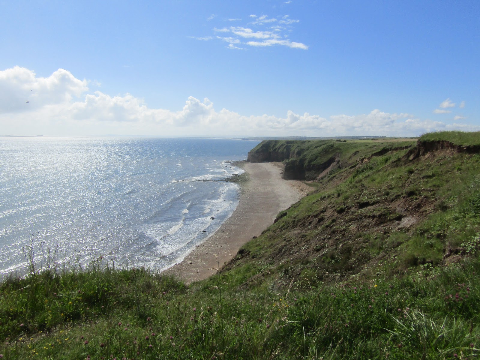
There are plenty of sign posts to mark my route, the "Durham Heritage Coast", the "English Coast Path" and the "Durham Coast Half Marathon". The path runs along the cliff tops above Chemical Beach to Nose's Point.

Turning right and heading inland a little the path passed some modern sculpture, where looking south I could see onto Blast Beach. I could see Beacon Hill in the distance.
Dropping a little to cross a narrow metal bridge the path rises again into the National Trust area. Following the path through a gate, the paths I was following soon turned left onto a grass path along the tops above Blast Beach. Self heal grew in patches along the sides.
I continued passed a path that leads down to Blast Beach, passed an ECP sign pointing right to a railway bridge, I followed the half marathon signs straight ahead. Before the path bends round to the right I could see Beacon Hill and below Hawthorn Hive with its solitary pill box.

I continued right until the path reached a fence by the railway line. Here the half marathon route turned right and headed back up to the ECP crossing over the railway bridge. I made the decision to turn left down a path that followed on the eastern side of the railway line.
All along my walk, the air was full of the sounds of little birds singing. Occasionally I caught sight of a kestrel, riding the thermals along the cliffs edge.

A little way along is a style that takes you over the railway lines, which had been the route I had intended to take. However after I saw another path down to my left which led to some steep steps down to Hawthorn Hive, I decided to explore the steep steps down to the Hive.

On reaching the beach I turned right. I was on the secluded beach with the pill box I had seen from above. Someone had used coloured stones to make a large pattern in the sand. Unfortunately I could not make out the pattern or take a picture.
Walking the short distance along the beach I crossed Hawthorn Burn and took a path up towards Hawthorn Dene passing what I think is what is left of some lime kilns, the path took me up under the central arch of the railway bridge. The rabbits were too quick for me to get a photo, one even ran right passed me and all I got was a photo of a patch of ground.

In places it was a steep short climb, with a twist in the path taking me up through the shade of the Dene. The smell of wild garlic hung in the air. A turn to the left and the path came out in sunshine, continuing level for a short while before dropping a little back under another arch on the bridge, crossing back under the railway line.

A short climb and I was following the eastern side of the fence that runs by the railway line. The last time I was here the fence was in the process of being replaced, with what you see below. Reaching a style over the line I crossed over and walked up the Beacon Hill.

The last few times I have been here with Anne and Callum and Declan we had to walk round the field and come in passed the building as all the cattle were standing at the south end of the field. Today they were at the north end so I was able to come straight across to the Beacon Hill 85m trig point. The cattle look like long horned cattle, like you see on the old westerns.


Returning to the path outside of the field I had a short rest. Taking in the views that stretched far out to the south. I had a cup of hot chocolate and took the time to apply some sun-cream. It was very hot and I could feel myself burning.
After my break I returned to the ECP crossing the railway line. The signs I were following took my left onto a grass path by a large field to the south of Shippersea Bay. As the path follows the coast it turns south between high hedges which gave a little shade, then it was back out into the sun. This area was all new to me and I was enjoying the views.
From a grass track the paths joined a tarmac track that came from Easington Colliery to my right. I was now in an area called Fox Holes.

The paths turned right following around the top of Horden Dene. Before dropping under the welcome shelter of some trees. The path twists and turns towards a railway bridge, just before the bridge it turns left onto a narrow path that drops and climbs, twists and turns its way on the south side of Horden Dene back into the sunshine. Walking towards the coast a sign had been put up showing a slight change in the path due to coastal erosion.

After a short rise the path crosses a style and turns right by a fence as it turns down hill. Cross another style and I followed high wooden steps down to the bottom of Warren House Gill. Over another style and turned left on the track towards the sea.
A marathon sign pointed right up a steep looking slippery bank. I was almost sliding back down part of the bank on my hands and knees when I saw wooden steps to my right, leading up. I was beginning to think this was some half marathon, with all the ups and downs, it did not look an easy run. At the top of the steps I was met by a couple of butterflies. Which reminds me I saw loads on today's walk.

I was now in an area with notice boards of details of the industrial past and how nature is reclaiming. With details of another walk around the area. I just continued along the ECP and marathon route.
Another rise and drop with a steep climb out. The path looped around the coast then headed inland towards Horden. The path turns left over a stream as it heads back down hill, towards the sea, between gorse bushes and a steep sided gill.

Signs led me up stone steps, fortunately these were easier to walk up than the previous high wooden steps I had come across on my walk.

The path continued south and I passed a sign that claims, if I looked back (north) I could see Souter Lighthouse.
Continuing south I passed a metalwork tern, before the path drops and bends to the right.

At a fork in the path I followed the left fork, and a yellow arrow, dropping down beneath some trees to a road. There were no marking here so I took a turn left down towards the sea and Horden Beach.

The path turns right below Hartlepool Point and crosses over Castle Eden Burn at Dene Mouth.

Up the other side I continued along the path. The path loops around the coast turning inland up towards Blackhall Colliery at Blue House Gill. I followed the path back towards the sea and continued along the coast passed a place called Dead mans. I turned up towards the car park, this may be where I start my next walk along the coast.

After a look at the signs I returned to the coast and had a break on the "Jarratt's" bench. Out at sea I could see 12 large ships at anchor, when I started my walk I only counted 7. The signs show it is 6 miles to Seaham, the way I had walked I had covered 9 miles. Not to worry it was such a nice day.
Looking south down the coast I could see Hartlepool.

After my break I started back, apart from a couple of detours to look down onto the beaches I returned almost on the same route.


Dropping down the high steep wooden steps into Warren House Gill I noticed a pill box almost buried on the side of the path.


Walking by the bottom of Beacon Hill, I did not go back up to the trig point.


After passing under the arch and turning right, into the shade of the trees, instead of continuing down to the beach Hawthorn Hive, the way I had come. I decided to turn left down the footpath into Hawthorn Dene, passed a small cave, crossed the footbridge and climbed out into an open meadow.

At the top of the path I turned right and followed the ECP sign to the railway line. Instead of crossing the line at the style as I could have on my way out, I turned left and continued up a rise following the ECP on the west side of the railway line.

I turned right over the bridge on the ECP and continued across an area of high grasses to the cliff edge. Numerous butterflies and birds were disturbed as I passed. This was when I noticed the birds had been quiet for some time, must be the heat.
At the cliff edge I turned left and followed the ECP northwards, taking a last look onto Blast Beach. One of the signs shows that the beach has been used in a film as an alien planet, due to the industrial impact on the shore.

I then continued along the ECP back to my car. Looking down onto the Seaham Piers, I could see waves crashing over the North East Pier.

It had been a lovely day, very warm. I had covered just over 31km with 530m climb.
More to follow
Boz North
Details correct at time of walking.
If you have enjoyed reading my walk or found it useful you may also like to read other walks I have done on The English Coastal Path or other areas. Please check out the links on the right hand side.
No comments:
Post a Comment